Islands of the Stockholm Archipelago
Around 24,000 islands, islets and skerries lie east of Stockholm. Visit Sweden counts 30,000, because that figure includes bare rock. Either way, a dozen of them are places you can realistically reach — and only a few are on a guided tour route.
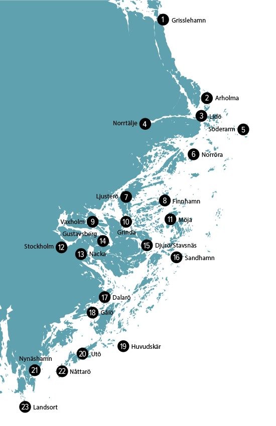
How the archipelago is arranged
It helps to think in three bands. The inner archipelago is wooded, sheltered and close — Fjaderholmarna sits twenty-five minutes from the quay. The middle band, around Grinda and Svartso, is where the islands thin out and the water opens. The outer band, past Sandhamn and Rodloga, is granite, low scrub and horizon.
The whole system runs from Oja, south of Nynashamn, to Vaddo north of Norrtalje, and covers about 1,700 square kilometres of which only 530 is land. It is still rising out of the sea at roughly three millimetres a year, left over from the last ice age.
Fjaderholmarna
The nearest islands to the city, about 25 minutes out. Close enough that almost every sightseeing cruise passes them, and the usual first taste of the archipelago. Restaurants, a boatyard and open rock make it a genuine destination rather than a waypoint.
Getting there: Passed by most cruises; the wooden-boat and live-guided trips both name it on the route.
Vaxholm
The town treated as the gateway to the archipelago, roughly an hour from the city. Wooden houses in ochre and cream, a working harbour, and a fortress on the island opposite. It has the range of restaurants, bars and cafes that most archipelago islands do not.
Getting there: The ferry excursion lands here for about 90 minutes; the kayak day paddles its shoreline.
Grinda
A small green island in the middle archipelago, run largely as a nature reserve. Grinda Wardshus, the island inn, serves a traditional menu in a genuine archipelago setting. Swimming beaches, meadows and short walking paths make it a classic day trip.
Getting there: Reachable on the public ferry network rather than the guided cruises.
Sandhamn
The sailing capital, out on the eastern edge where the deep-water channel comes in. Regattas, a long sand beach and a harbour full of masts in July. One of three deep-draught shipping entrances to the whole archipelago passes here.
Getting there: Beyond the range of the day cruises; reached by Cinderella boats in season.
Uto
A former iron-mining island in the south, with some of the oldest mine workings in Sweden. Now better known for cycling, swimming and a bakery people plan a day around. It carries the restaurants, bars and cafes to sustain a full visit.
Getting there: Public ferry territory; the sailing day works this southern water.
Moja
Middle archipelago, low and green, with a fishing history and a scattering of villages. Quieter than Grinda or Sandhamn and slower to reach, which is the point. Strawberries and smoked fish are the local production.
Getting there: Not on the day-tour routes — a public-ferry destination.
Svartso
A farmed island, unusually green for the archipelago, with a working dairy heritage. Forest paths, a village shop and a lodge make it a favourite for slow weekends. It sits between Grinda and Moja in the middle band.
Getting there: Public ferry only.
Finnhamn
A cluster of islands rather than one, with a hostel, a cafe and rock to sit on. Popular with kayakers and with anyone who wants an overnight without a hotel. The water between the islets is sheltered and shallow.
Getting there: Paddling territory; not on a cruise route.
Varmdo
One of the largest islands, close enough to the mainland to be reached by road. Artipelag, the art gallery and restaurant on its shore, is a destination in its own right. It also carries a range of restaurants, bars and cafes.
Getting there: Passed on the longer cruises; reachable by bus.
Ljustero
A large island to the north, connected by a short ferry and popular for summer houses. Forest, farmland and a long shoreline rather than a single sight. It gives a sense of how ordinary archipelago life actually works.
Getting there: Northern water, outside the day-cruise routes.
Dalaro
A historic customs and pilot station in the south, with wooden villas and a sheltered harbour. Divers come for the wrecks in the surrounding water. The village keeps its nineteenth-century shape.
Getting there: Southern archipelago; reached by road or public boat.
Rodloga
Far out in the northern outer band, small, rocky and almost treeless. This is what the archipelago looks like when the forest gives up and only granite is left. A handful of houses and a great deal of horizon.
Getting there: Outer archipelago; well beyond a day tour.
Which islands you will actually see
On a guided tour, realistically: Fjaderholmarna, the shoreline around Djurgarden and Blockhusudden, Stora Hoggarn, Tegelon, and Vaxholm from the water. The kayak day gets you onto rock near Vaxholm and the sailing day moors at an island in the south. Everything else needs the public ferry network, which is covered on how to get to the Stockholm Archipelago.
Pick the tour that reaches the water you want
Inner-archipelago cruises, a kayak day around Vaxholm, or a full day under sail to a southern island.
Once you have chosen an island, where and what to eat in the Stockholm Archipelago covers the inns and the fish, and the Stockholm Archipelago tours FAQs handle the practical detail. Stockholm Archipelago Tours lists every departure with its price and rating.